Drones have evolved beyond their military origin – they are now powerful tools commonly used by the commercial sector, and deliver unprecedented efficiency and accuracy across various industries.
According to Goldman Sachs, the market for drones is expected to reach an impressive $100 billion market cap by 2020. The integration of un-mannedaerial vehicles (UAVs) into common industries has created an opportunity that is too great to ignore.
As 2D and 3D models become the default tools that industries use to expedite workflows and save time, there is a growing need for understanding the drone phenomenon.
What Is Drone Mapping?
Drone mapping is the process of mapping geographical expanses, and measuring real-world objects or scenes. The result of the process is usually constructed in a map, a defined measurement or a 3D model.
The technique used when mapping with drones is called photogrammetry. It is not a new discovery; rather,this is a technique that has been in use for centuries.
As the science of making measurements from photographs, photogrammetry has been a fundamental concept behind the creation of modern maps, and other geographical measurement devices.
However, drone mapping takes photogrammetry to another level. With the help of UAVs and their ability to fly at extremely low altitudes and take ultra-high-definitionpictures, the results are highly accurate and precise.
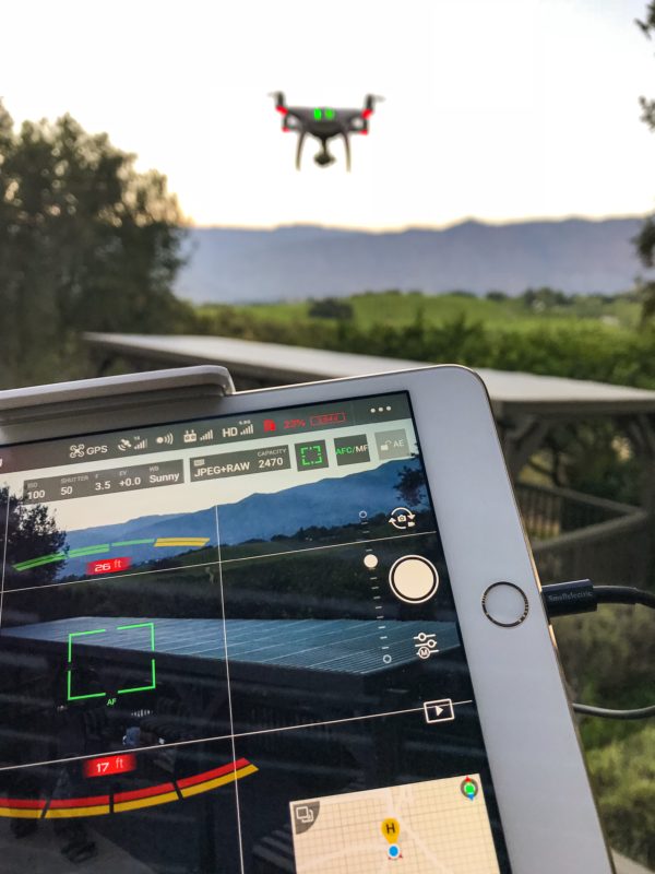
When utilizing a drone to capture data, users usually mount cameras at the very bottom of the drone. The UAV is then flown over the predefined area, andthe user is required to take multiple overlapping photographs of the ground below.
Specifying the flight path beforehand, and ensuring enough image overlap results in complete coverage of the defined area – in other words, no area is left unattended when you proceed to processthe images.
As technology continues to streamline workflows, the droneindustry has also grown to include advanced software that enables users to process images quickly.
Modern software is equipped with different formats that adequately account for a comprehensive survey of land, buildings, andother infrastructural elements. The end result is a highly accurate measurement of the length, area, andvolume of the mapped area.
Where Are Drones Being Used Currently?
From the firefighters looking out for potential water points in case of a forest fire, to oil and gas companies conducting pipeline checks – drones have massivepotential to offer to a wide array of industries.
The commercial sector provides the fastest growth opportunity for the drone market. Goldman Sachs reports that this sector of the economy will alone account for more than $13 billion spending by 2020.
Here are some industries that increasingly leveragingthe potential of drones:
The Construction Industry
As one of the foremost advocates of drone integration, the construction industry greatly benefits from the operational efficiencies that are afforded by aerial data via drone mapping.
Construction projects can span across hectares, and engineers and other stakeholders don’t always have the time to step foot on site to gain valuableinsights for the project completion.
Drones provide precise linear and volumetric measurements from the sky, thereby ensuring real-time data transfer whichcan result in timely and strategic decision making.
In fact, the use of drones can increase the safety on a construction site by 55%.
Land Surveying
Geospatial Intelligence Officers and Land Surveyors can also derive great benefit from integrating drones into their business workflows.
The efficiency and speed of drone photogrammetry ensuresthat surveyors can collect, and analyze data much faster compared to traditional methods.
With the added capability of using RTK Rovers and Total Stations, modern drones allow land surveyors to speed up delivery at a dramatically increased rate.
Real Estate Industry
Real estate stakeholders can utilize a drone vehicle in different ways. For example, drones are used by high-end hotels that require high-definition 3D models of the entire resort to allow customers a virtual walk-through of the entire place.
If you have ever looked at a standard satellite image, you are well aware that the image lacks detail and depth. Drone mapping can solve this issue by taking high-definition pictures, and forming detailed aerial maps that lend visual insights into property details. Additionally, users can opt for the help of a licensed land surveyor to contour lines and accurate borders.
Drone mapping also allows real estate owners to utilize technology such as orthomosaics. In short,orthomosaicsenable landowners to get an accurate estimate of the entire boundary around their estate.
The Agriculture Industry
Drones have been touted to provide a much needed technological boost to the agriculture industry, as they lend farmers with a powerful birds-eye view of their entire crop.
From identifying plant diseases to indexing the entire crop to help conduct a yield analysis, drone mapping can pave the way for increased yields and healthier crops.
Drone Flights Involve Multiple Considerations
As a fundamental component for delivering increased efficiency and efficacy to a growing number of industries, drones are complex machines that require strongniche expertise to master.
For instance, the software used for drone mapping plays an important role. There are different types of drone mapping software such as acquisition software, or processing software which are designed to cater to different user needs.
Hence, users need to be clear on their objective with a drone vehicle. There are also several other things to consider before you can fly away your drone vehicle.
While anyone can fly UAV as a hobby, as soon as money is involved,it becomes a commercial operation. This is the point where the FederalAviation Associationand federal law gets involved.
Not only is the pilot required to be certified (including a background check and trial), but UAV flights are restricted to certain ‘zones’ or geographical areas that have been cleared for UAV flights. The FAA also restricts night-time flights without prior permission.
Leave It To The Experts!
The drone industry is expected to grow to more than $82.1 billion in annual revenue by 2025. The Economic Reportindicates the rising consumer market as one of the main reasons behind this unprecedented growth.
As drones become more advanced, there is a growing need for drone experts who can control these complex machines while ensuring the best results for their clients.
Optingfor drone professionals, like Los Angeles Aerial Image, warrants that every criterion– from government approval to the right software – is being met.
With years of photography experience and UAV flight training, Los Angeles Aerial Image utilizes cutting edge technology to capture the highest quality images and 3D maps. From mapping out your construction 3D model to conducting real estate photography, we provide extensive photography and aerial imaging services – contact us now!
